Neighborhoods are complex systems with spatial signals that help decode their stories. We integrate innovative GIScience, public health, and statistical approaches to explore, understand, and promote healthy places.
Research Program Themes
1.
Defining how place impacts & interacts with health
We focus on complexity surrounding the measurement, mapping, and distillation of multiple health outcomes and associated social determinants of health at varying scales, to gain a greater understanding of disease prevalence.
2.
Identifying disparities of access & health outcomes
In collaboration with clinical and public health teams, we explore the relationship of accessibility as a function of health outcomes, from food access disparities to availability of evidence-based medications for opioid use disorder.
3.
Building engaged, participatory infrastructures
We collaborate with policymakers, community members, researchers, and software engineers to brainstorm ways of integrating complex information about the natural, social, health, & built environments — using human-centered design thinking.
4.
Integrating spatial thinking in research design
Spatial effects can violate core components of the standard counterfactual framework used for evaluation, making treatment effects difficult to assess. We refine and improve methods to consider & account for spatial interactions.
Select Research Projects
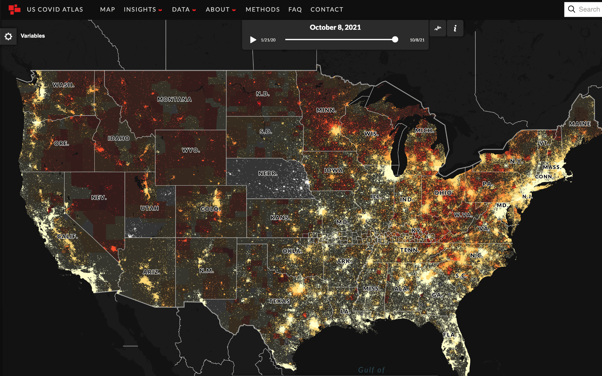
Since early 2020, we’ve made spatial statistics accessible in the web browser, encouraging users to explore the pandemic from its start to today. In the latest push, we’re humanizing the data with oral histories from across the country. We also explore how regional social determinants of health impact COVID.
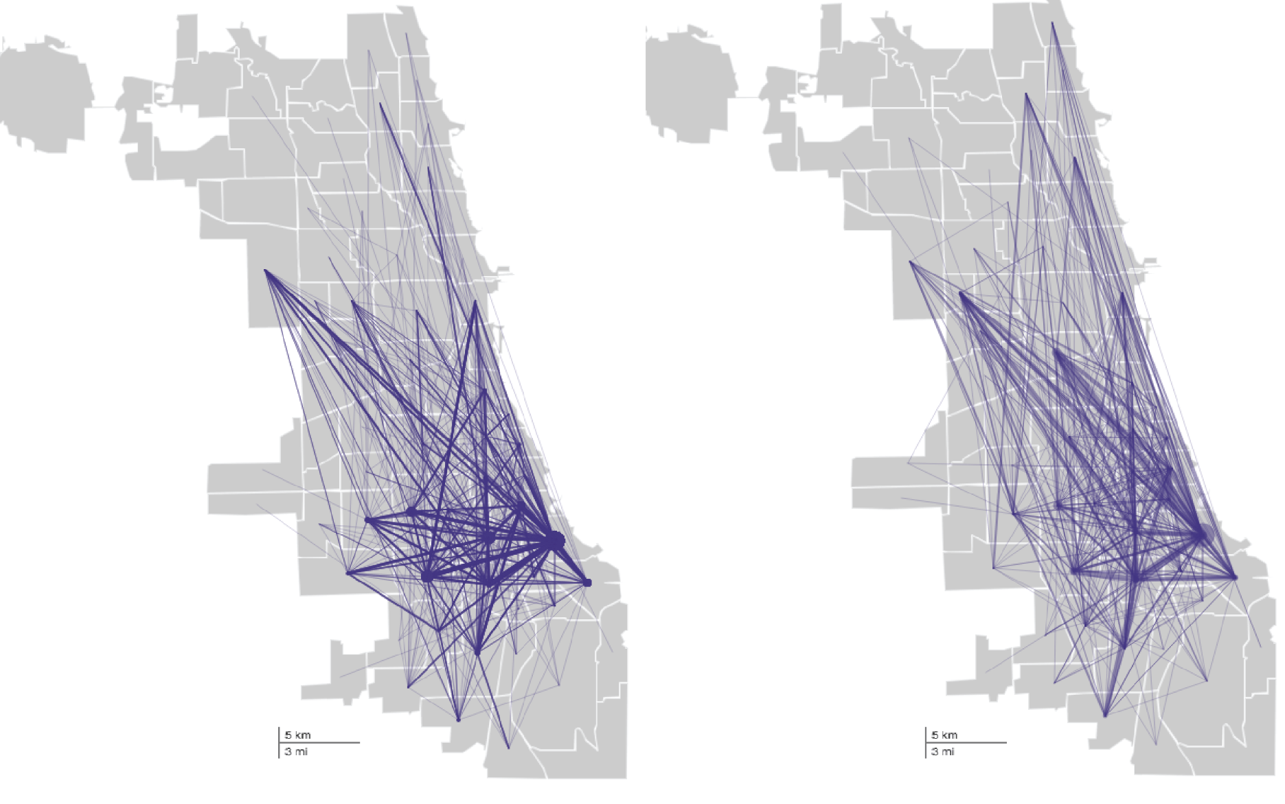
Place and Social-Spatial Networks
We have multiple projects exploring how neighborhood connections between people can be better understood to prioritize places, individuals, or groups for life-saving and harm-reducing health interventions.
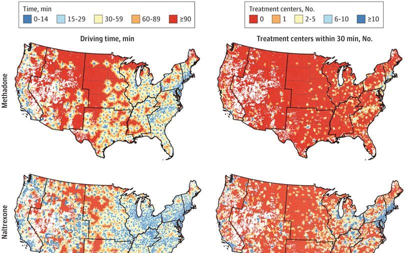
Measuring Opioid Risk Environments
We are the geospatial core leads at the JCOIN Methodology and Advanced Analytics Resource Center, and collaborate with many other teams to measure opioid risk environments, access to medication for opioid use disorder, and implement quasi-experimental research designs to evaluate spatial impacts.
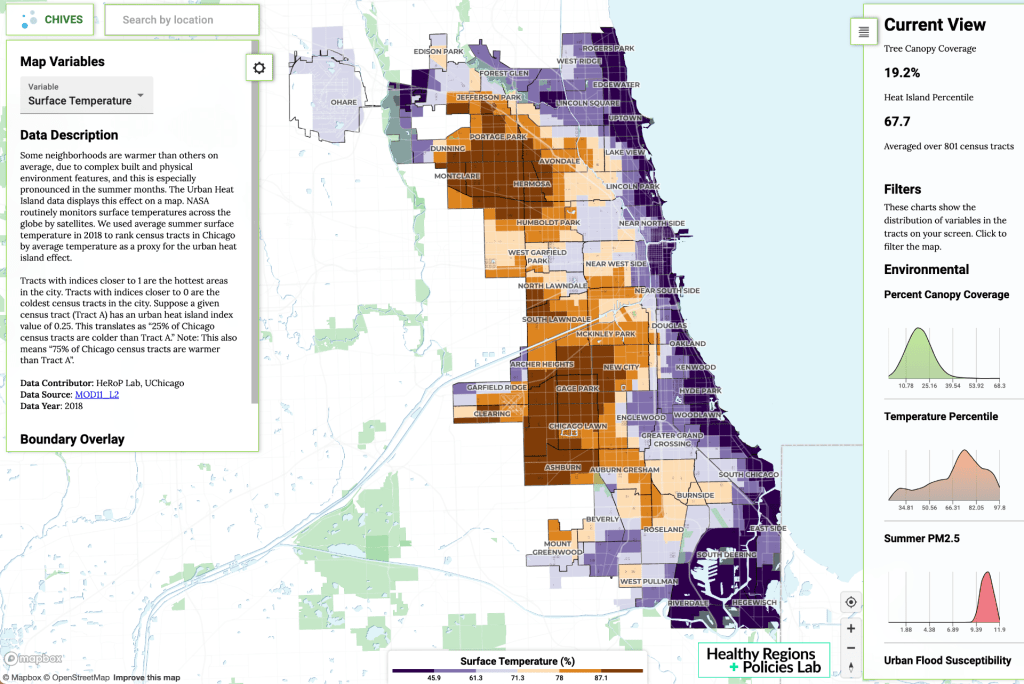
Decision Supports for Environmental Justice
A handful of key metrics―tree cover, air pollution estimates, heat island effects, traffic volumes, and social vulnerability index― help to reveal where in the city people face particular challenges. Following years of collaboration with different groups, we’re now fine-tuning ChiVes to support community efforts.
Latest News from HeRoP Lab
-

US COVID Atlas Wins Honorable Mention in 2021 Innovation by Design Awards
The US COVID Atlas is honored to be recognized by Fast Company’s Innovation by Design Awards for 2021, receiving honorable mention in the Pandemic Response category. The project is led by the Healthy Regions & Policies Lab and the Center for Spatial Data Science at University of Chicago. We are thrilled to be included among Read more
-

Evaluating Access for Opioid Risk Environments
This summer we are pleased to share research highlights from our Spatial Data Science Summer Fellows, showcasing their work on the US COVID Atlas and opioid risk environment research projects. This week, Data Science Fellow Rachel Vigil (BA ’22) shares an update on her work on evaluating measures of access for opioid risk environment research projects. Read more
-
We’re Hiring Research Assistants for Fall 2021 👋
The Healthy Regions & Policies Lab (HEROP) is hiring three new Research Assistant (RA) positions for the Fall 2021 quarter. These positions are open to undergraduate and graduate students. Pay starts at $15/hr, with a time commitment of 8-10 hrs/week. See below for full descriptions. Interested students can apply here. Returning RAs should also indicate Read more
-

Constructing a Model to Study the Built Environment
This summer we are pleased to share research highlights from our Spatial Data Science Summer Fellows, showcasing their work on the US COVID Atlas and opioid risk environment research projects. This week, Built Environment Data Science Fellow Christian Villaneuva (BA ’22) shares an update on their work developing a model for measuring the built environment’s impact on Read more
-
Interactive Web Mapping with Opioid Environment Data
This summer we are pleased to share research highlights from our Spatial Data Science Summer Fellows, showcasing their work on the US COVID Atlas and opioid risk environment research projects. This week, Summer Institute in Social Research Methods (SISRM) Fellows Margot Bolanos-Gamez (BS and BA ‘23) and Ziqian (Alexa) Jin (BA ‘24) share an update on Read more
-

Explorations into US COVID Atlas Data Infrastructure
This summer we are pleased to share research highlights from our Spatial Data Science Summer Fellows, showcasing their work on the US COVID Atlas and multiple opioid risk environment research projects. This week, Spatial Infrastructures Data Engineering Fellow Jinfei Zhu (MAPPS ‘22) shares an update on her work with the US COVID Atlas. This piece Read more
Looking for a research experience?
We are not hiring other staff or UIUC student hourly researchers at this time. To get on the waitlist, contact us with your interest and resume.
The Healthy Regions & Policies Lab is supported in part by the following organizations.